The Blue Motorways Beneath Birmingham: Why Canal Towpaths Are the Commute You've Been Missing
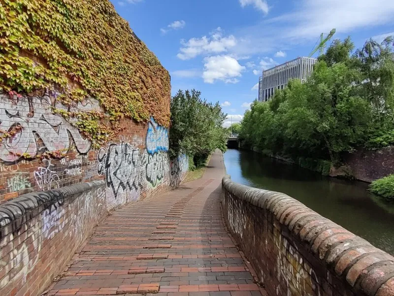
Photo: Mat Fascione , CC BY-SA 2.0, via Wikimedia Commons
There's a moment, somewhere between Gas Street Basin and Brindleyplace, when the noise of the city just falls away. The traffic on Broad Street might as well be on another planet. Instead, you've got the gentle lap of water, the odd narrowboat puttering past, and a flat, uninterrupted stretch of towpath stretching out ahead of you. For the cyclists who've stumbled onto Birmingham's canal network, it feels like finding a cheat code.
The thing is, most people still haven't found it. Despite Birmingham boasting roughly 35 miles of navigable canal — a network that genuinely rivals Venice for sheer mileage — the towpaths remain one of the city's most underused cycling assets. That's starting to change, but not nearly fast enough.
A Network Built for Movement (Just Not Cyclists — Yet)
Birmingham's canals were engineered during the late 18th century to shift coal, iron, and goods across a region that was rapidly becoming the workshop of the world. The towpaths alongside them were built for horses, not bikes, which goes some way to explaining why cycling infrastructure along them has historically been, shall we say, an afterthought.
But the bones of something brilliant are absolutely there. The main arteries — the Birmingham Main Line, the Wyrley & Essington Canal, the Grand Union heading southeast toward Solihull and beyond — connect neighbourhoods, employment centres, and green spaces in ways that no road can replicate. And crucially, they do it without a single set of traffic lights or a single white van driver cutting you up at a roundabout.
Canal & River Trust, the charity responsible for maintaining the network in England and Wales, has been gradually acknowledging the towpaths' potential as active travel corridors. In Birmingham specifically, there's been meaningful investment in surfacing on key stretches — particularly around the city centre — with compacted gravel and tarmac sections replacing the muddy, rutted paths that used to put casual cyclists off entirely.
"We've seen a real shift in how people are using the towpaths post-pandemic," says one Canal & River Trust volunteer ranger we spoke to near Farmers Bridge Locks. "Cycling numbers have gone up significantly. People discovered them during lockdown and they just kept coming back. The challenge now is making sure the surface quality and the signage keep pace with that demand."
The Routes Worth Knowing About
So where should you actually ride? Here's a quick rundown of the towpath stretches that Birmingham cyclists rate most highly right now.
Gas Street Basin to Kings Norton — This is arguably the city's best urban towpath ride. Following the Worcester & Birmingham Canal southward, you pass through Bournville, Stirchley, and out toward the leafier suburbs. The surface is decent for most of its length, and the route is almost entirely car-free. It's a legitimate commuter option for anyone living along the southern corridor.
Farmers Bridge to Perry Barr (Birmingham & Fazeley Canal) — Heading north from the city centre, this route takes you through Aston and up toward Perry Barr. It's rougher in places and navigation can be a bit hit-and-miss without a decent map, but the recent resurfacing around Aston Junction has made a real difference. Great for a weekend explore.
Smethwick to Wolverhampton via the Main Line — The old and new main lines running through the Black Country are underappreciated gems. The riding is fast and flat, the industrial heritage is genuinely fascinating, and you can cover serious distance without touching a road. A brilliant option for longer weekend rides.
The Problems Nobody Wants to Ignore
For all the genuine progress, it would be doing the network a disservice to pretend everything's rosy. Signage remains patchy at best and non-existent at worst. Junction points — where towpaths split or where you need to navigate up onto a road briefly — are frequently unmarked, which is fine if you know the network intimately but genuinely confusing for newcomers.
Surface quality is also inconsistent. Some stretches are beautifully maintained; others turn into obstacle courses after a wet week, with exposed tree roots, puddles the size of small ponds, and low-hanging branches that seem to have been growing unchecked since the Industrial Revolution.
There's also a persistent tension between cyclists and pedestrians on the towpaths — particularly in the city centre sections where foot traffic is heavy. This isn't unique to Birmingham, but it does matter. Faster riders blasting through without warning gives the whole cycling community a bad reputation, and it actively discourages people from seeing the towpaths as welcoming shared spaces.
"What we really need is a properly joined-up signage system and some investment in the rougher rural stretches," says Marcus, a regular commuter who rides the Worcester & Birmingham Canal into Brum from Northfield three days a week. "The city centre bits are great now, honestly. But once you get out toward the ring road and beyond, it's a bit of a lottery what condition the path is going to be in."
What Good Could Look Like
It's worth looking at what's been achieved elsewhere for a sense of what Birmingham's canal network could become. The Leeds & Liverpool Canal towpath has sections that are genuinely world-class cycling infrastructure — well-surfaced, clearly signed, and actively promoted as a leisure and commuter route. Closer to home, sections of the Stratford-upon-Avon Canal have been improved to a standard that makes them feel genuinely accessible to all abilities.
Birmingham's city council has included canal towpaths in its wider cycling strategy, and there's growing alignment between Transport for West Midlands, Canal & River Trust, and local cycling advocates around the idea of the towpath network as a serious active travel asset. The pieces are there. The question is pace and funding.
For now, though, the towpaths offer something rare in a city of Birmingham's size: genuine breathing space. A chance to get from A to B — or just to get out and pedal for the sheer pleasure of it — without fighting for road space.
Get Out There
If you've never ridden Birmingham's canals, honestly, just go. Download a canal map from the Canal & River Trust website, pick a dry day, and give yourself an hour or two to explore. You'll almost certainly get slightly lost, definitely find a stretch of path that makes you wonder why you've been riding roads all this time, and probably start planning your next towpath commute before you've even got home.
The Second City's best cycling secret is hiding in plain sight. It's time more of us found it.